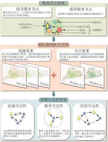
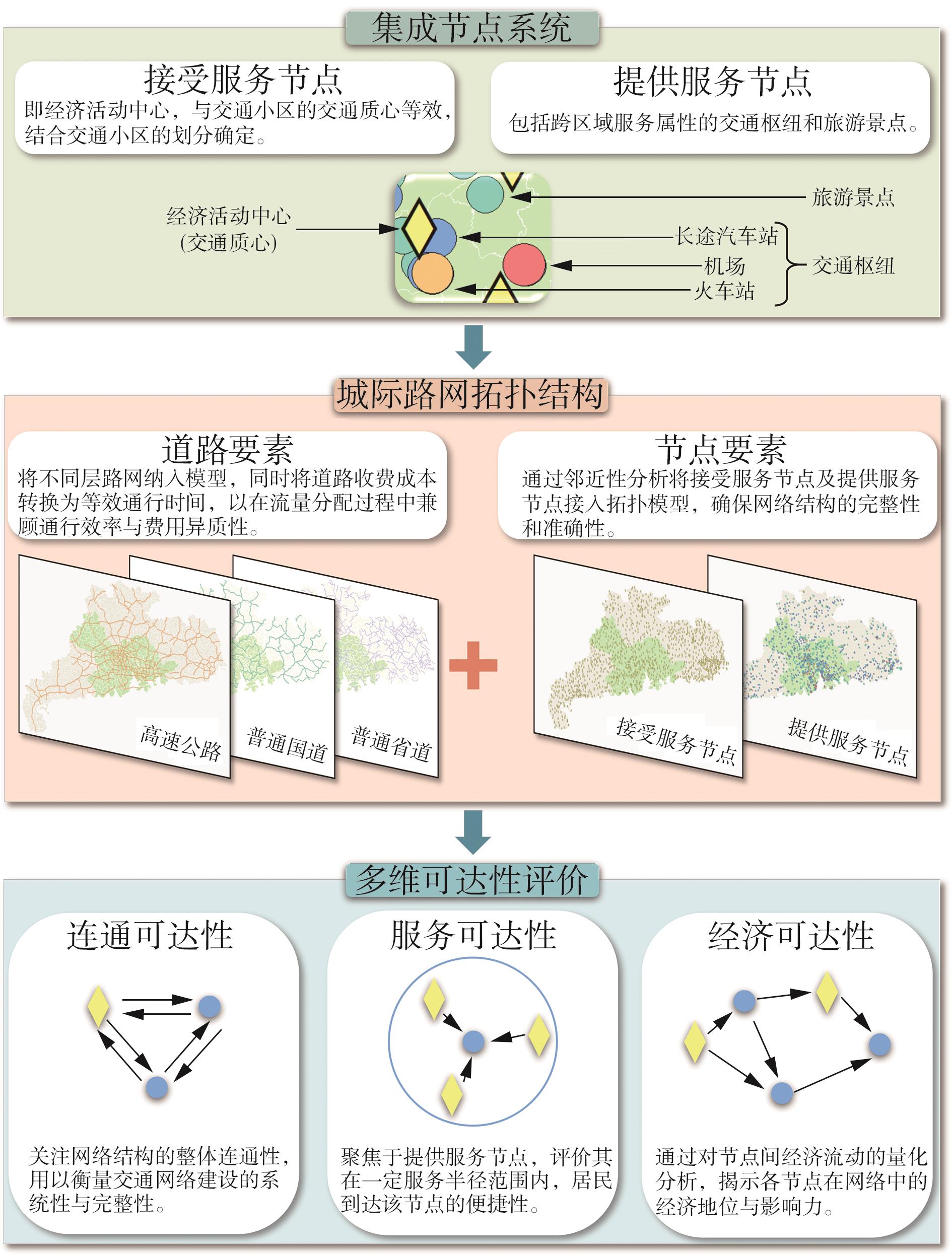
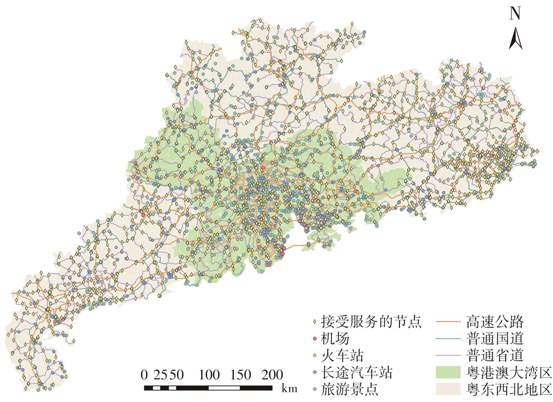
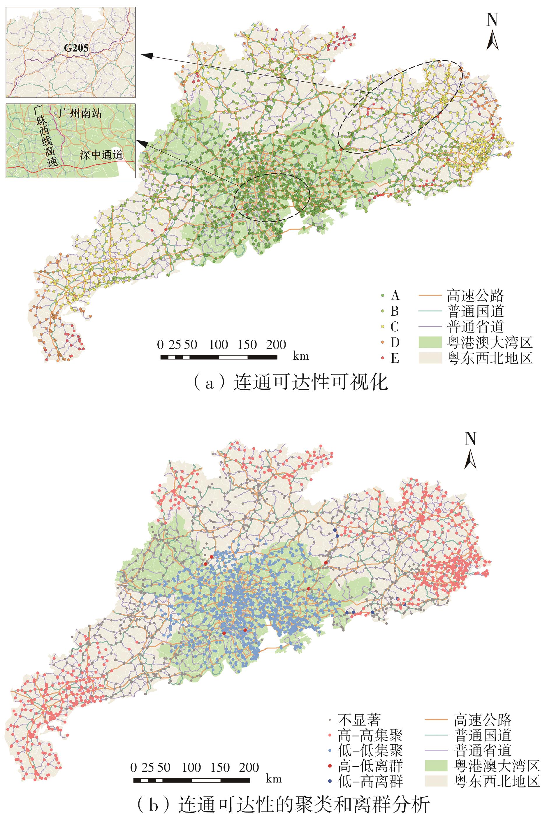
| [1] |
RAZA A, ZHONG M, AKUH R,et al .Public transport equity with the concept of time-dependent accessibi-lity using Geostatistics methods,Lorenz curves,and Gini coefficients[J].Case Studies on Transport Policy,2023,11:100956/1-13.
|
| [2] |
BORISOV A I, GNATYUK G A .Assessment of transport accessibility of the Arctic regions of the Republic of Sakha (Yakutia)[J].Transportation Research Procedia,2022,61:289-293.
|
| [3] |
GONÇALVES G M, MARASCHIN C, MAFFINI A L .An adapted centrality index to assess spatial accessibility in street networks:application to two medium-sized ci-ties in Brazil[J].Journal of Transport Geography,2025,126:104238/1-12.
|
| [4] |
CAVALLARO F, BRUZZONE F, NOCERA S .Accessibility to cultural economy opportunities by high-speed rail[J].Travel Behaviour and Society,2025,40:101037/1-16.
|
| [5] |
YU L, CUI M .How subway network affects transit accessibility and equity: a case study of Xi’an metropolitan area[J].Journal of Transport Geography,2023,108:103556.
|
| [6] |
DU Q, ZONG X, LI Y,et al .Resilience optimization of bus-metro double-layer network against extreme weather events[J].Transportation Research Part D:Transport and Environment,2024,135:104378/1-20.
|
| [7] |
TAN Z, SHAO S, ZHANG X,et al .Sustainable urban mobility:flexible bus service network design in the post-pandemic era[J].Sustainable Cities and Society,2023,97:104702/1-13.
|
| [8] |
LIU H, RAHMAN M, KARNER A .Bus network redesigns and public transit equity analysis:evaluating system-wide changes in Richmond,Virginia[J].Travel Beha-viour and Society,2023,31:151-165.
|
| [9] |
ZHANG H, ZHAN B, OUYANG M .Enhancing accessibility through rail transit in congested urban areas:a cross-regional analysis[J].Journal of Transport Geo-graphy,2024,115:103791/1-13.
|
| [10] |
TSUMITA N, KIKUCHI H, VICHIENSAN V,et al .Urban railway network expansion on transit oriented development:improvement in accessibility in four Asian developing cities[J].Asian Transport Studies,2023,9:100097/1-12.
|
| [11] |
YANG L,EOM S, SUZUKI T .Measuring railway network performance considering accessibility levels in ci-ties worldwide[J].Journal of Transport Geography,2021,96:103211/1-11.
|
| [12] |
JIANG S, CAI C, XIAO L .Intercity accessibility and equity: empirical study of high speed rail and air travel network in China[J].Case Studies on Transport Policy,2023,13:100995/1-11.
|
| [13] |
BANSAL S,SEN J .Network assessment of Tier- Ⅱ Indian cities’airports in terms of type,accessibility,and connectivity[J].Transport Policy,2022,124:221-232.
|
| [14] |
ALESCHENKO V V, ALESCHENKO O A, PETROV Y V,et al .Transport accessibility of rural territories of the Siberian Federal District[J].Transportation Research Procedia,2023,68:389-394.
|
| [15] |
MARTÍN B, ORTEGA E, CUEVAS-WIZNER R,et al .Assessing road network resilience:an accessibility comparative analysis[J].Transportation Research Part D:Transport and Environment,2021,95:102851/1-15.
|
| [16] |
ZHU Y, HU Y, COLLINS J M .Estimating road network accessibility during a hurricane evacuation:a case study of hurricane Irma in Florida[J].Transportation Research Part D:Transport and Environment,2020,83:102334/1-13.
|
| [17] |
KITA H, YOTSUTSUJI H, ASAKA R,et al .Estimation method for interurban accessibility:a highway performance measure indicating smooth and safe traffic flow[J].Transportation Research Procedia,2016,15:709-720.
|
| [18] |
WEN H, YE Y, ZHANG L .Optimizing road networks in underdeveloped regions for improving comprehensive efficiency integrated by accessibility,vulne-rability and socioeconomic interaction[J].Reliability Engineering & System Safety,2024,243:109848/1-20.
|
| [19] |
MITROPOULOS L, KAROLEMEAS C, TSIGDINOS S .Road network accessibility assessment during flood events by using infrastructure facility-based indices[J].International Journal of Disaster Risk Reduction,2025,122:105475/1-20.
|
| [20] |
WANG F, LIU Z, XUE P,et al .High-speed railway development and its impact on urban economy and population:a case study of nine provinces along the Yellow River,China[J].Sustainable Cities and Society,2022,87:104172/1-18.
|
| [21] |
CUI Y, XU S, JIANG Y,et al .Transportation infrastructure development and subjective socio-economic status:a quasi-experiment in establishing rural bus stations in China[J].Research in Transportation Business & Management,2023,49:101006/1-9.
|
| [22] |
ZHUANG S, XIA N, GAO X,et al .Coupling coordination analysis between railway transport accessibility and tourism economic connection during 2010—2019: a case study of the Yangtze River Delta[J].Research in Transportation Business & Management,2024,55:101134/1-15.
|
| [23] |
FENG X .Coupling and coordinated development of traffic accessibility and regional tourism economy[J].Research in Transportation Business & Management,2023,49:101010/1-17.
|
| [24] |
MAO X, CHEN X .Does airport construction narrow regional economic disparities in China?[J].Journal of Air Transport Management,2023,108:102362/1-14.
|
| [25] |
BUTTON K .Transport economics[M].4th ed.Cheltenham:Edward Elgar Publishing Limited,2022.
|
| [26] |
MEYER M D, MILLER E J .Urban transportation planning:a decision-oriented approach[M].New York:McGraw-Hill Book Company,1984.
|
| [27] |
PORTA S, CRUCITTI P, LATORA V .The network analysis of urban streets:a primal approach[J].Environment and Planning B,Planning and Design,2006,33(5):705-725.
|
| [28] |
YE Y, WEN H, ZHANG L .Vulnerability assessment of multi-level road networks considering the impact of traffic demand[C]∥Proceedings of CICTP 2024.Shenzhen:ASCE,2024:2777-2786.
|
| [29] |
CASCETTA E, CARTENÌ A, HENKE I,et al .Economic growth,transport accessibility and regional equi-ty impacts of high-speed railways in Italy:ten years ex post evaluation and future perspectives[J].Transportation Research Part A:Policy and Practice,2020,139:412-428.
|
| [30] |
MEI Z, XU S, OUYANG J .Spatial pattern and evolution of road network accessibility in the Pearl River Delta[J].Tropical Geography,2014,34(1):27-33,103.
|
| [31] |
GHERGULESCU I, MUNTEAN C .Assessment in game-based learning:foundations,innovations,and perspectives[M].New York:Springer New York,2012:355-378.
|
| [32] |
BONES E J, BARRELLA E M, AMEKUDZI A A .Implementation of evidence-based design approaches in transportation decision making[J].Transportation Research Part A:Policy and Practice,2013,49:317-328.
|