华南理工大学学报(自然科学版) ›› 2025, Vol. 53 ›› Issue (6): 131-139.doi: 10.12141/j.issn.1000-565X.240196

• 智慧交通系统 • 上一篇    下一篇

轨迹数据驱动的职住地识别及出行活动特征分类方法

谢坤1(), 邢馨元2, 董宏辉1, 董春娇1, 陈元朵3   

  1. 1.北京交通大学 交通运输学院,北京 100044
    2.同济大学,交通学院,上海 201804
    3.乌鲁木齐市城市综合交通项目研究中心,新疆 乌鲁木齐 830063
  • 收稿日期:2024-04-19 出版日期:2025-06-10 发布日期:2024-11-01
  • 作者简介:谢坤(1982—),男,博士生,主要从事道路交通研究。E-mail: xiekun@bjtu.edu.cn
  • 基金资助:
    国家自然科学基金项目(72371017);北京交通大学中央高校基本科研业务费专项资金资助项目(2022RC023)

Method for Workplace and Residence Identification and Travel Activity Classification Driven by Trajectory Data

XIE Kun1(), XING Xinyuan2, DONG Honghui1, DONG Chunjiao1, CHEN Yuanduo3   

  1. 1.School of Traffic and Transportation,Beijing Jiaotong University,Beijing 100044,China
    2.School of Transportation,Tongji University,Shanghai 201804,China
    3.Urumqi Urban Comprehensive Transportation Project Research Center,Urumqi 830063,Xinjiang,China
  • Received:2024-04-19 Online:2025-06-10 Published:2024-11-01
  • Supported by:
    the National Natural Science Foundation of China(72371017)

摘要:

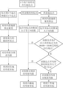
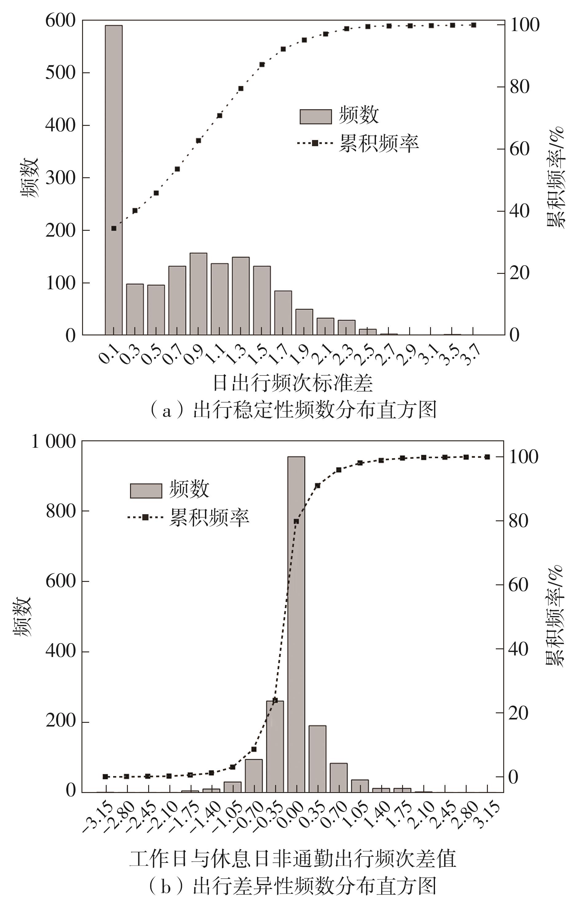
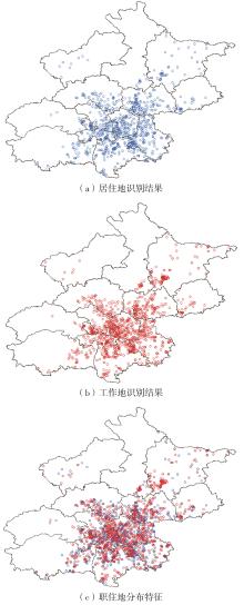
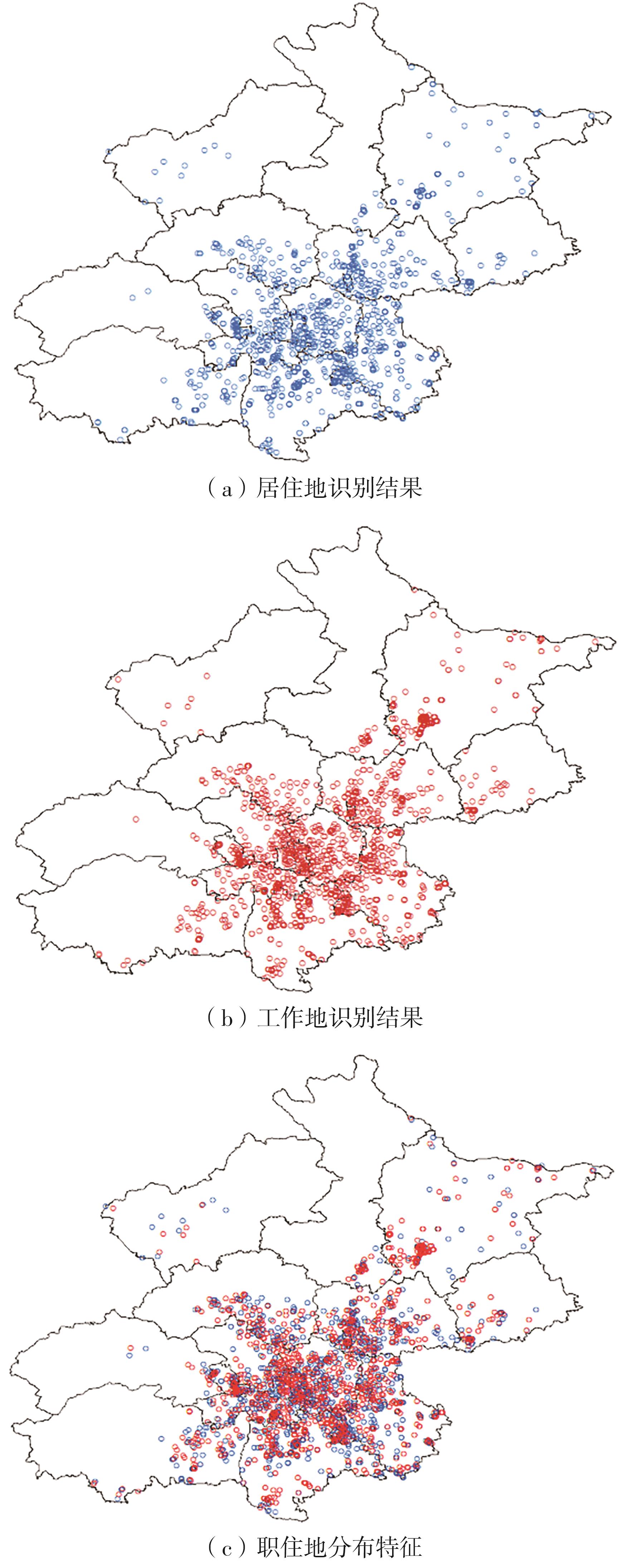
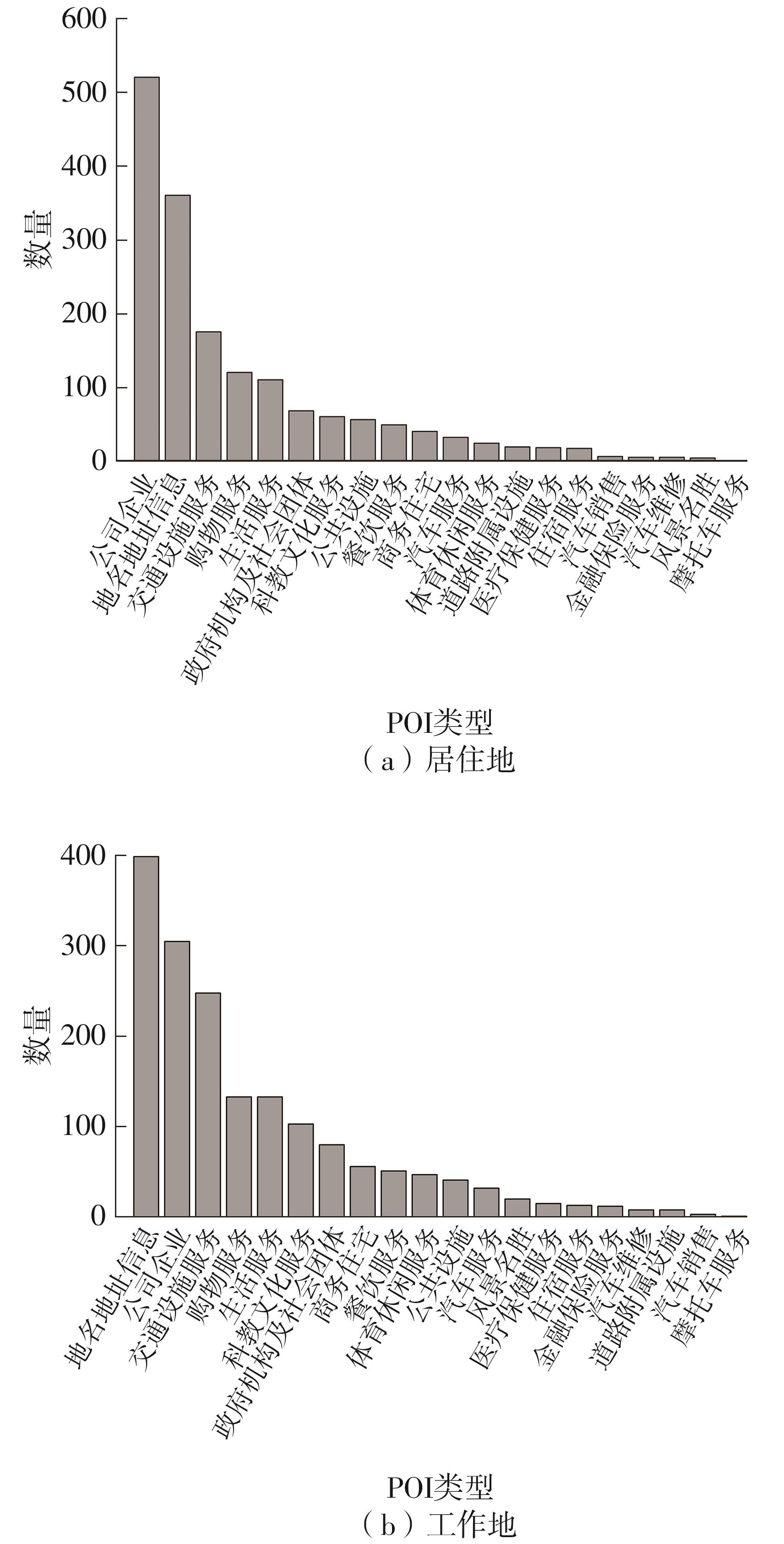
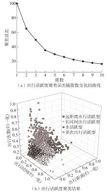
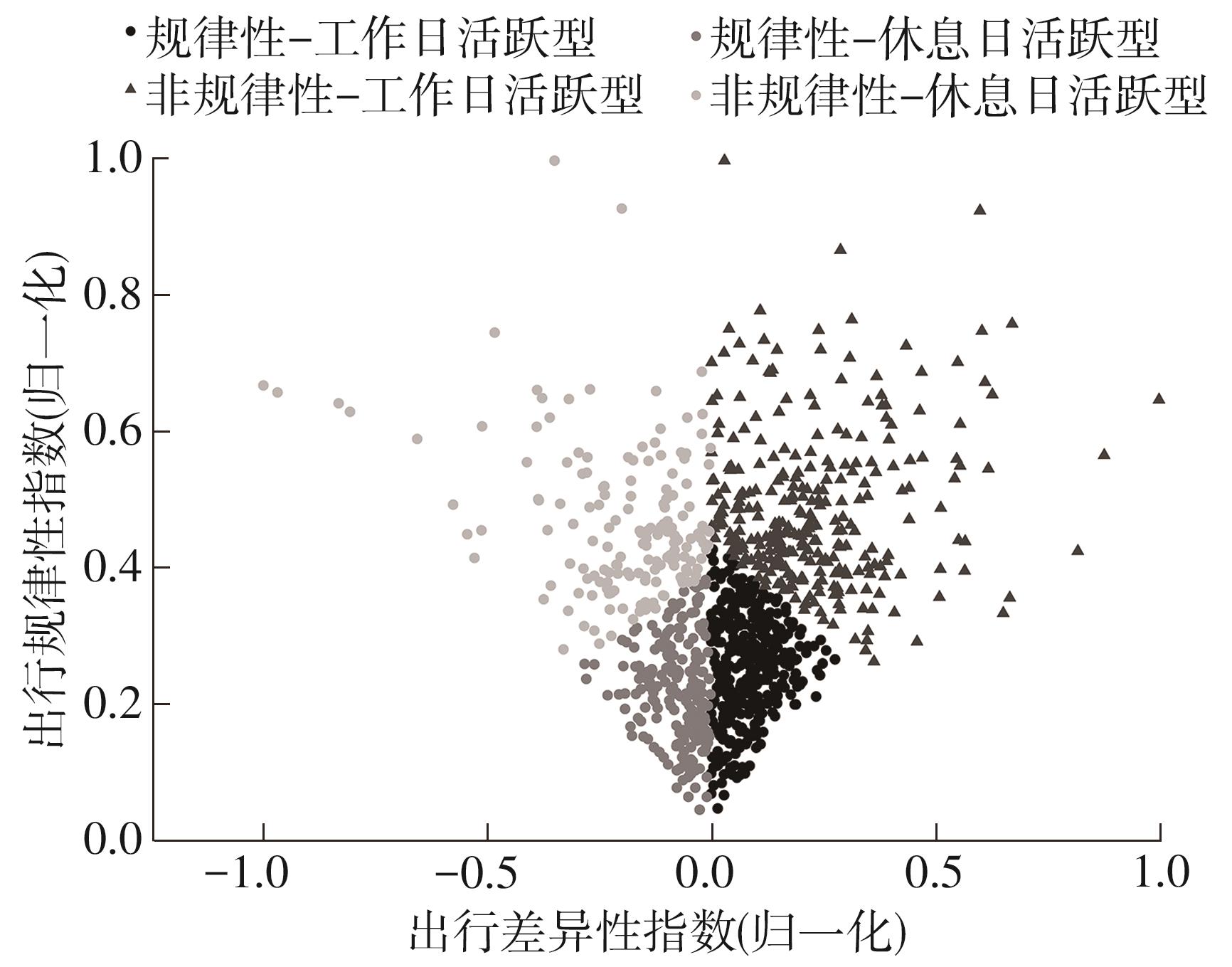
车辆行驶轨迹蕴含丰富的出行特征信息,通过研判轨迹中的职住地及出行兴趣点(POI),可以深度分析出行活动特征和规律。该文以每日出行活动第1个起点和最后1个讫点构成的点集作为居住地的可能点集,其余起讫点构成工作地与兴趣地可能点集。在可能点集的基础上,提出了基于均值偏移聚类和时空双重约束的职住地识别方法,结合簇密度、簇内点平均停留时间和出行时间范围3个条件,识别居住地、工作地和兴趣地坐标。基于KD-Tree算法为每一类地点坐标匹配邻近POI数据,得到职住地具体位置与名称。在职住地和出行兴趣点识别的基础上,结合出行次数、出行距离和出行时间表征出行活跃度,以稳定性和差异指标表征出行规律性,采用K-means++聚类分析算法,研判出行活动特征类别。以北京市连续34 d均有出行活动的1 708辆私家车行驶轨迹数据为例进行实证研究,结果表明:构建的职住地识别方法研判的职住地分布特征与现实规律相符,具有较高的精度和可靠性;基于K-means++算法的出行活动特征分类表明特大城市的出行活动以活跃型为主,占比达59.84%,其中多次出行活跃型占比最大,为31.09%;活跃型的出行活动在工作日以规律性出行为主、在非工作日以非规律性出行为主。该研究可为交通基础设施布局优化提供理论支撑。

关键词: 城市交通, 职住地, 出行活动, 轨迹数据, 聚类算法

Abstract:

Vehicle trajectory data contains rich information about travel behavior. By analyzing the origins and destinations within these trajectories-such as places of residence, work, and travel-related points of interest (POIs)-researchers can deeply examine travel activity characteristics and patterns. This study identified potential residential locations based on the first origin and the final destination of each day’s travel activities, while other origins and destinations form the candidate sets for workplaces and interest points. Building on these candidate sets, the paper proposed a method for identifying places of residence and employment using mean shift clustering with spatiotemporal constraints. The identification is based on three criteria: cluster density, average dwell time within the cluster, and the time range of travel activities. This approach enables the extraction of residential, work, and interest point coordinates. The KD-Tree algorithm was then used to match each identified coordinate with nearby POIs, providing specific names and locations for residences and workplaces. Based on the identification of workplace and travel interests, the study quantified travel activity levels using metrics such as travel frequency, distance, and time. It also characterized travel regularity using stability and variability indicators. A K-means++ clustering algorithm was employed to classify types of travel activity patterns. Taking 1 708 vehicles with travel activities for 34 days in Beijing as an example, the empirical research was conducted based on the driving trajectory data. The research results indicate that the distribution characteristics of workplace and residential areas determined by the proposed method is consistent with practical laws, with high accuracy and reliability. The classification of travel activity characteristics based on the K-means++ algorithm reveals that active travel patterns dominate in megacities, accounting for 59.84% of total activities. Among these, frequent travelers constitute the largest subgroup at 31.09%. Active travel behaviors primarily manifest as regular trips on weekdays and irregular trips on non-working days. This research provides theoretical support for optimizing transportation infrastructure planning.

Key words: urban transportation, workplace and residence, travel activities, trajectory data, clustering algorithm

中图分类号: