
收稿日期: 2023-12-19
网络出版日期: 2024-03-05
基金资助
广东省自然科学基金资助项目(2022A1515011974);广东省交通规划设计研究院集团股份有限公司资助项目(20221615)
Research on the Construction and Evaluation Methods of the Perceptual Space of Unmanned Vehicles
Received date: 2023-12-19
Online published: 2024-03-05
Supported by
the Natural Science Foundation of Guangdong Province(2022A1515011974)
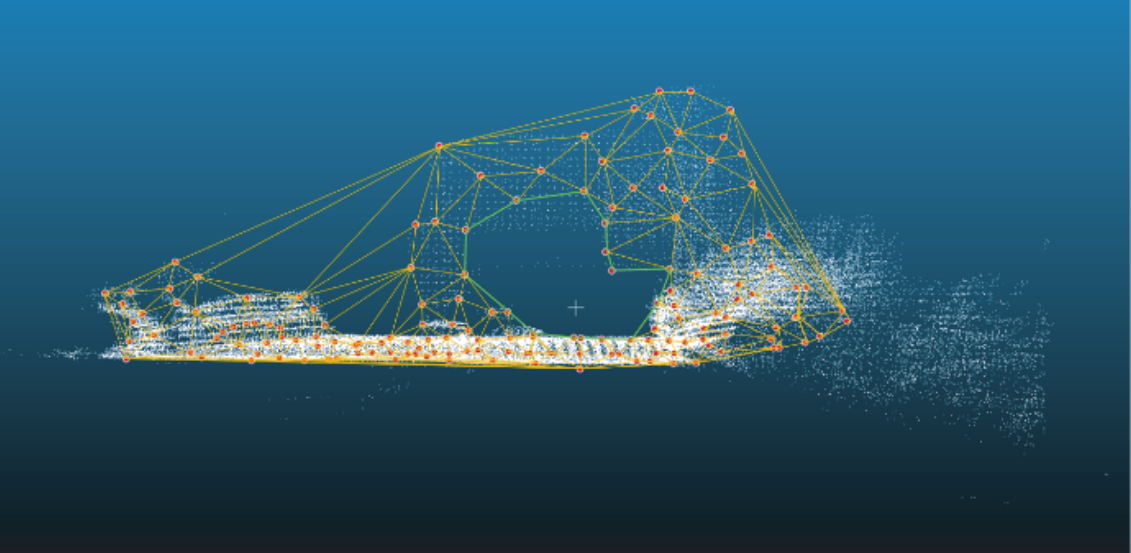
无人驾驶车辆的传感器代替人眼感知道路空间的信息,保障一定感知空间的可感知性,是无人驾驶安全运行的重要前提。因此,该文在国内外研究文献调研以及相关软硬件技术分析的基础上,分析了当前无人驾驶车辆感知技术的局限性,包括激光雷达、摄像头和毫米波雷达等传感器的识别范围和特性;利用激光雷达和组合导航系统对道路的现实信息进行采集,进一步利用收集到的点云数据、定位信息、同步定位与建模算法构建无人驾驶车辆的三维感知空间,实现了道路的三维数字模型构建。同时在三维点云地图中进行测距能力、水平视场角和垂直视场角等参数数学表达模型构建,利用空间坐标变换方法,将传感器识别范围内的三维点云数据进行分离,并转换到统一的坐标系下。最后利用Delaunay三角化方法,构建出能够反映感知空间特性的三维模型,从而实现三维感知空间的可感知性的判定方法。为验证该文方法的实用性和准确性,利用实地采集的数据对算法进行了测试。测试结果表明,该文提出的方法具有良好的鲁棒性,能够在复杂的道路环境中稳定工作,可以准确评估无人驾驶车辆的感知能力。这一研究成果不仅为无人驾驶车辆的道路设计和安全评估提供了科学依据,也为无人驾驶技术的进一步发展和应用提供了强有力的技术支持。
王晓飞 , 王子旗 , 丁振中 , 郭月利 , 姚江贝 . 无人驾驶车辆感知空间的构建及可感知性判别[J]. 华南理工大学学报(自然科学版), 2024 , 52(11) : 134 -140 . DOI: 10.12141/j.issn.1000-565X.230777
The sensor of unmanned vehicles replaces human eyes to perceive the information of road space is an important prerequisite for the safe operation of unmanned vehicles. Therefore, based on the domestic and international research literature research as well as the analysis of relevant software and hardware technologies, this paper analyzed the limitations of the current perception technology of unmanned vehicles, including the recognition range and characteristics of sensors such as LiDAR, camera and millimeter-wave radar. And it collected the real information of the road by using the LiDAR and the combination of navigation system, and further constructed the three-dimensional perception space of the unmanned vehicle with the collected point cloud data, the localization information, and the synchronous positioning and modeling algorithms, which realize the three-dimensional digital model construction of the road. At the same time, the mathematical expression model construction of parameters such as ranging ability, horizontal field of view angle and vertical field of view angle was carried out in the 3D point cloud map, and the spatial coordinate transformation method was utilized to separate the 3D point cloud data within the recognition range of the sensors and convert them to a unified coordinate system. Finally, the Delaunay triangulation method was used to construct a 3D model that can reflect the characteristics of perceptual space, so as to realize the perceptability of 3D perceptual space. In order to verify the practicality and accuracy of this method, this paper tested the algorithm using data collected in the field. The test results show that the method proposed in this paper has good robustness and it can work stably in complex road environments and accurately assess the perceptibility of unmanned vehicles. This research result not only provides a scientific basis for the road design and safety assessment of unmanned vehicles, but also provides strong technical support for the further development and application of unmanned technology.
Key words: unmanned vehicle; laser radar; perceptual space; road safety
| 1 | 梁景盛,麻博文,孙刚禹,等 .基于Bow-Tie模型的交通事故分析[J].建模与仿真,2022,11(4):1151-1160. |
| LIANG Jingsheng, MA Bowen, SUN Gangyu,et al .Traffic accident analysis based on Bow-Tie model[J].Modeling and Simulation,2022,11(4):1151-1160. | |
| 2 | ZHENG O, ABDEL-ATY M, WANG Z,et al .AVOID:autonomous vehicle operation incident dataset across the globe[J].arXiv preprint arXiv:2303.12889,2023. |
| 3 | LI B, ZHANG T, XIA T .Vehicle detection from 3D lidar using fully convolutional network[J].arXiv preprint arXiv:1608.07916,2016. |
| 4 | ZHOU Y, TUZEL O .Voxelnet:end-to-end learning for point cloud based 3D object detection[C]∥Proceedings of the IEEE Conference on Computer Vision and Pattern Recognition.Salt Lake City:IEEE,2018:4490-4499. |
| 5 | YANG Z, SUN Y, LIU S,et al .3DSSD:point-based 3D single stage object detector[C]∥Proceedings of the IEEE/CVF Conference on Computer Vision and Pattern Recognition.Seattle:IEEE,2020:11040-11048. |
| 6 | CHEN Y, LIU S, SHEN X,et al .Fast point R-CNN[C]∥Proceedings of the IEEE/CVF International Conference on Computer Vision.Seoul:IEEE,2019:9775-9784. |
| 7 | GUAN H, LI J, CAO S,et al .Use of mobile LiDAR in road information inventory:a review[J].International Journal of Image and Data Fusion,2016,7(3):219-242. |
| 8 | JUNG J, OLSEN M J, HURWITZ D S,et al .3D virtual intersection sight distance analysis using lidar data[J].Transportation Research Part C:Emerging Technologies,2018,86:563-579. |
| 9 | GONZáLEZ-GóMEZ K, IGLESIAS L, RODRíGUEZ-SOLANO R,et al .Framework for 3D point cloud modelling aimed at road sight distance estimations[J].Remote Sensing,2019,11(23):2730/1-14. |
| 10 | LIOI A, de SANTOS-BERBEL C, BASSANI M,et al .3D modeling of highway guardrails for sight distance assessment[J].Journal of Transportation Engineering,Part A:Systems,2021,147(11):04021078/1-9. |
| 11 | 林泓熠,刘洋,李深,等 .车路协同系统关键技术研究进展[J].华南理工大学学报(自然科学版),2023,51(10):46-67. |
| LIN Hongyi, LIU Yang, LI Shen,et al .Research progress on key technologies in the cooperative vehicle infrastructure system[J].Journal of South China University of Technology(Natural Science Edition),2023,51(10):46-67. | |
| 12 | 华为终端有限公司 .问界 M9 参数配置表[EB/OL].(2023-11-24)[2024-02-26].. |
| 13 | 广州小鹏汽车科技有限公司 .P7 I配置表[EB/OL].(2023-11-6)[2024-02-26].. |
| 14 | TESLA.Model S车主手册[EB/OL].(2023-3-28)[2024-02-26].. |
| 15 | 张大印 .自动驾驶车载激光雷达关键技术研究[D].成都:电子科技大学,2019. |
| 16 | :公路路线设计规范 [S]. |
| 17 | WOOD D P .Safety and the car size effect:a fundamental explanation[J].Accident Analysis & Prevention,1997,29(2):139-151. |
| 18 | 安晓亚,朱余德,晏雄锋 .卷积神经网络支持下的建筑物选取方法[J].测绘学报,2023,52(9):1574-1583. |
| AN Xiaoya, ZHU Yude, YAN Xiongfeng .A building selection method supported by graphconvolutional network[J].Acta Geodaetica et Cartographica Sinica,2023,52(9):1574-1583. |
/
| 〈 |
|
〉 |
地址:广州 五山 华南理工大学17号楼 邮政编码:510640
电话: 020-87111794 邮箱:journal@scut.edu.cn

