华南理工大学学报(自然科学版) ›› 2023, Vol. 51 ›› Issue (7): 129-138.doi: 10.12141/j.issn.1000-565X.220583

所属专题: 2023年交通运输工程

• 交通运输工程 • 上一篇    下一篇

基于激光雷达里程计的高速公路三维建模方法

黄炎1 符锌砂1 曾彦杰2 李百建1   

  1. 1.华南理工大学 土木与交通学院,广东 广州 510640
    2.广东省交通运输规划研究中心,广东 广州 510101
  • 收稿日期:2020-09-09 出版日期:2023-07-25 发布日期:2023-01-20
  • 通信作者: 李百建(1987-),男,博士后,讲师,主要从事道路工程相关理论的研究。 E-mail:bjian_li@163.com
  • 作者简介:黄炎(1988-),男,博士生,主要从事智能交通系统研究。E-mail:yann_h0918@163.com
  • 基金资助:
    国家自然科学基金资助项目(51978283)

3D Modeling Method of Highway Based on Lidar Odometer

HUANG Yan1 FU Xinsha1 ZENG Yanjie2 LI Baijian1   

  1. 1.School of Civil Engineering and Transportation,South China University of Technology,Guangzhou 510640,Guangdong,China
    2.Guangdong Provincial Transport Planning and Research Center,Guangzhou 510101,Guangdong,China
  • Received:2020-09-09 Online:2023-07-25 Published:2023-01-20
  • Contact: 李百建(1987-),男,博士后,讲师,主要从事道路工程相关理论的研究。 E-mail:bjian_li@163.com
  • About author:黄炎(1988-),男,博士生,主要从事智能交通系统研究。E-mail:yann_h0918@163.com
  • Supported by:
    the National Natural Science Foundation of China(51978283)

摘要:

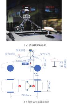
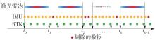
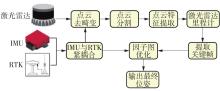
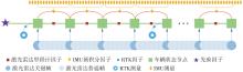
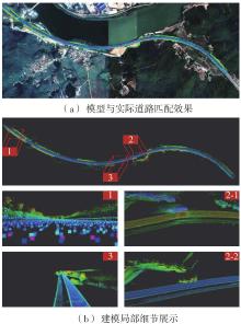
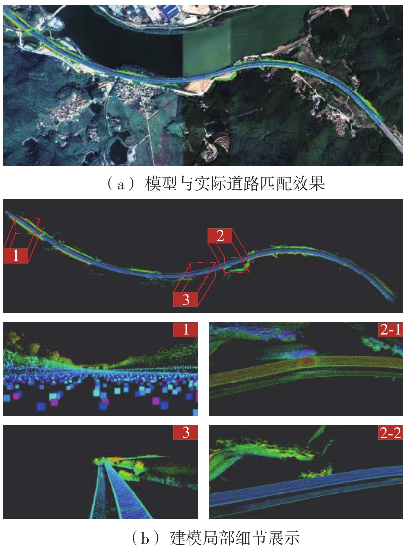
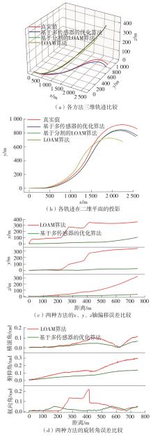
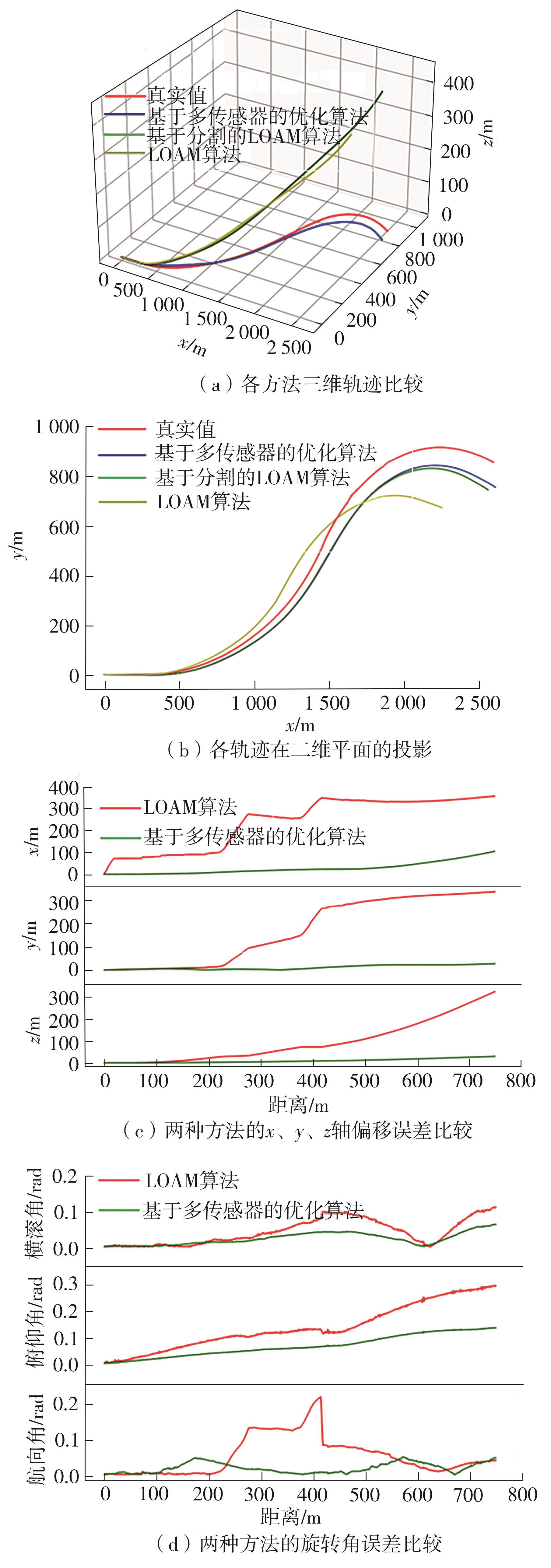
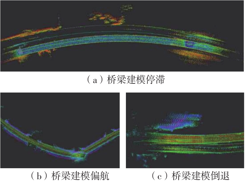
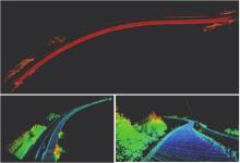
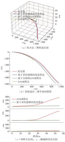
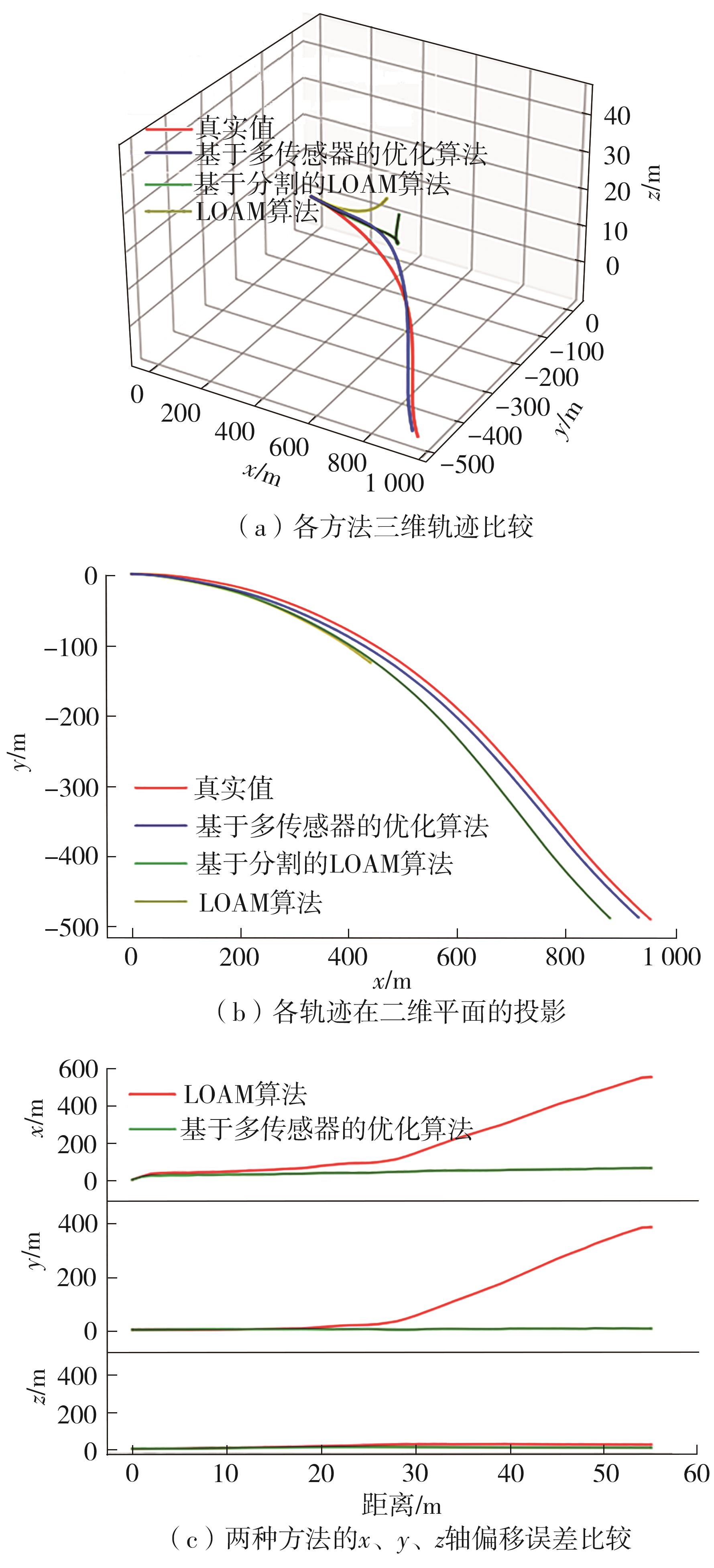
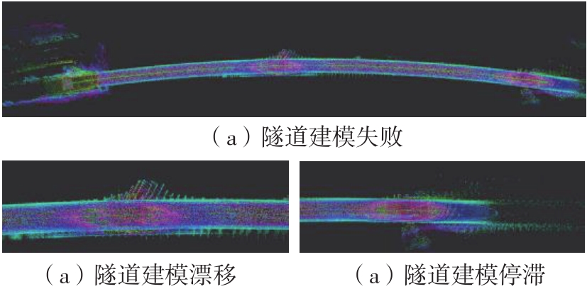
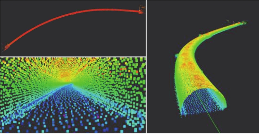
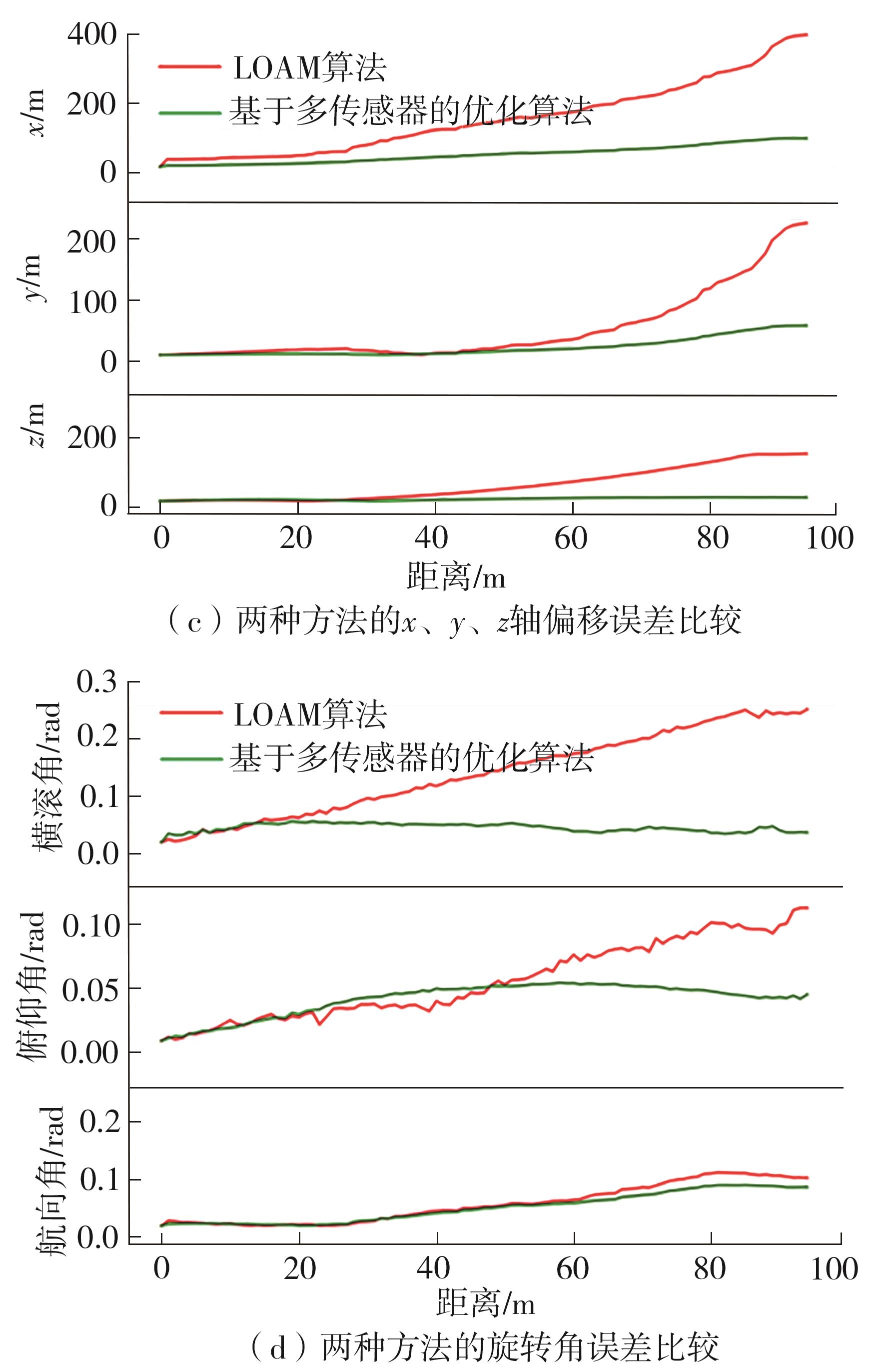
构建三维道路数字模型对智能车服务和道路管理具有重要意义。文中针对高速公路不同路段应用场景下车辆运行速度快、干扰噪声多、特征少和无回环检测辅助等一系列问题,提出一种以激光雷达信息为建模基础数据、激光雷达里程计与LOAM技术等多传感器融合的高速公路三维建模方法。首先,通过车载激光雷达获取道路场景的激光点云数据,使用激光雷达图像分割技术赋予每一个点有关构造物的标签,剔除道路上其他运动车辆的信息,减少建模噪声;其次,制定了一个精确的同步策略来对GNSS、IMU和激光雷达等传感器进行集成;在此基础上,结合惯性导航预积分结果、基于特征点云的位姿约束和RTK数据构建因子图,消除激光雷达里程计的累积误差,从而构建全局一致性的高速公路三维数字模型。为了保持姿态估计的有限数量,文中还引入了基于关键帧的滑动窗口优化策略。最后,分别采集高速公路场景中常见的3种路段(一般路段、桥梁和隧道路段)进行建模分析,结果表明,在具有挑战性的高速公路场景建模中,文中方法能够有效提高建模鲁棒性、精度以及模型有效性。

关键词: 激光雷达里程计, 高速公路, 三维建模, 因子图优化

Abstract:

The construction of 3D road digital model is of great significance for intelligent vehicle service and road management. In this paper, to solve the problems such as fast running speed, interference noise, few features and no loopback detection assistance existing in different sections of highway application scenarios, a three-dimension highway modeling method with lidar information as the modeling data base is proposed, in which multi-sensor fusion based on lidar odometry and LOAM technology is adopted. In the investigation, firstly, the point cloud data in different road scenarios are obtained by lidar, and the lidar image segmentation technique is used to assign each point a label about the structure and exclude the information of other moving vehicles on the road to reduce the modeling noise. Then, an accurate synchronization strategy is developed to integrate the sensors such as GNSS, IMU and lidar. On this basis, by combining the inertial navigation pre-integration results, the position constraint based on feature point cloud and the RTK data, a three-dimension highway digital model with global consistency is constructed to eliminate the cumulative error of the lidar odometry. Moreover, in order to maintain a finite number of attitude estimates, a sliding window optimization strategy based on key frames is introduced. Finally, three common road sections (general, bridge and tunnel) in the highway scenario are collected for modeling analysis, and the results show that the proposed approach can effectively improve the robustness, accuracy and validity in the challenging highway scenario modeling.

Key words: lidar odometry, highway, 3D modeling, factor graph optimization

中图分类号: